
Garmin BlueChart und Navionics Seekarten bei LEPPER marine
Als Nutzer von einem Garmin Gerät profitieren Sie von der Übernahme von Navionics durch Garmin. Viele Inhalte von Navionics fließen in die BlueChart Kartografie ein und parallel bietet Garmin spezielle Garmin Navionics+ und Garmin Navionics Vision+ Seekarten an.
Dieser Link zeigt Ihnen die Möglichkeiten Ihres Garmin Kartenplotters:
Vergleich Plotter Kompatibilität mit Garmin BlueChart und Garmin Navionics
Es ist wichtig zu beachten, dass die Seekarten in dieser Rubrik sowie den Unterrubriken ausschließlich mit entsprechend mordernen Garmin Kartenplottern (mit jeweils neuster Betriebssoftware) genutzt werden können.
Die Verwendung mit Plottern von Drittanbietern (außer Garmin) ist mit diesen Karten nicht möglich. Für andere Hersteller (sog. Navionics Drittanbieter Kartenplotter) außer Garmin schauen Sie bitte in dieser Rubrik
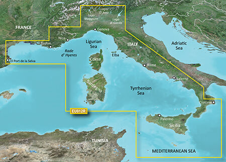
Details: Informationen Produktcode VEU012R Name Mediterranean Sea, Central-West Typ Garmin BlueChart g3 Vision Abdeckung Detailed coverage of the Mediterranean coast from Islas Medas, ES to Crotone, IT, including the coasts of France, Monaco, and the west coast of Italy. Also includes detailed coverage of Lago Maggiore, Lago D' Iseo, and Lago di Garda in Northern Italy. Island coverage features Corse, Sardegna, Sicilia, and Malta. Kompatibilität siehe Reiter Kompatible Plotter Kartenupdate Hier klicken
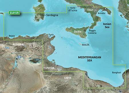
Details: Informationen Produktcode VEU013R Name Italy Southwest & Tunisia Typ Garmin BlueChart g3 Vision Abdeckung Italian coast: from Isola d'Ischia, south to Reggio Calabria, northeast to Brindisi, including Sicilia and southern part of Sardegna. African coast: from Golfe de Bejaia, Algeria to Banghazi, Libya. Kompatibilität siehe Reiter Kompatible Plotter Kartenupdate Hier klicken
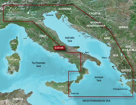
Details: Informationen Produktcode VEU014R Name Italy, Adriatic Sea Typ Garmin BlueChart g3 Vision Abdeckung Detailed coverage of several Italian lakes, the Po River and the Adriatic coast of Italy, Slovenia, Croatia, Albania, the western coast of Greece and southern Italy. Coverage includes eastern Sicily, the Straits of Messina, the Dalmatian Coast, the Gulf of Taranto, Lago Maggiore, Lago d'Iseo, Lago di Como and Lago d'Garda. Kompatibilität siehe Reiter Kompatible Plotter Kartenupdate Hier klicken
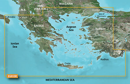
Details: Informationen Produktcode VEU015R Name Aegean Sea & Sea of Marmara Typ Garmin BlueChart g3 Vision Abdeckung Including all of the Greek coast and Aegean Sea; Turkey from Istanbul and Sea of Marmara to Antalya; and Brindisi, Italy. Kompatibilität siehe Reiter Kompatible Plotter Kartenupdate Hier klicken
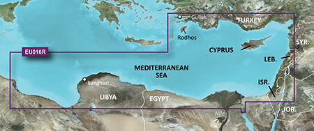
Details: Informationen Produktcode VEU016R Name Mediterranean Southeast Typ Garmin BlueChart g3 Vision Abdeckung From Güllük, Turkey east to include Cyprus, Syria, Lebanon and Israel, then west to Misratah, Libya. Kompatibilität siehe Reiter Kompatible Plotter Kartenupdate Hier klicken
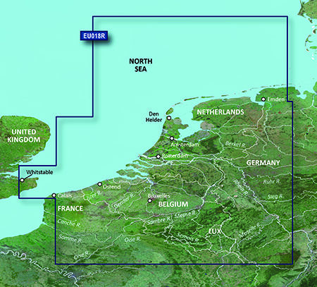
Details: Informationen Produktcode VEU018R Name The Netherlands Typ Garmin BlueChart g3 Vision Abdeckung Continental coverage: from Spiekeroog, Germany to Calais, France, including The Netherlands and Belgium coast entirely. Great Britain coverage: from Whitstable to Folkestone. Kompatibilität siehe Reiter Kompatible Plotter Kartenupdate Hier klicken
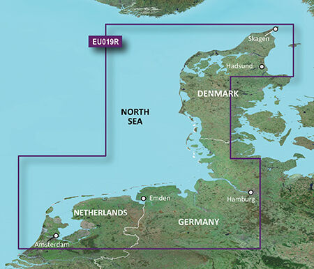
Details: Informationen Produktcode VEU019R Name Alborg-Amsterdam Typ Garmin BlueChart g3 Vision Abdeckung Includes detailed coverage from Ålborg Bugt to Amsterdam, The Netherlands, including Limfjorden, Hamburg, Bremen and Emden. Kompatibilität siehe Reiter Kompatible Plotter Kartenupdate Hier klicken

Details: Informationen Produktcode VEU021R Name Denmark East & Sweden Southeast Typ Garmin BlueChart g3 Vision Abdeckung Swedish coast: from Göteborg to Karlskrona, including Malmö and Trelleborg, as well as lakes Mjörn and Bolmen. Danish, German, and Polish coasts: Lemvig, Denmark to Szczecin, Poland, including Limfjorden, Skagen, Den., Copenhagen, Den., Stralsund, Ger., and the islands of Sjælland, Fyn, Møn, Falster, Lolland, Langeland and Fehmarn. Kompatibilität siehe Reiter Kompatible Plotter Kartenupdate Hier klicken

Details: Informationen Produktcode VEU041R Name Oslo-Skagerak-Haugesund Typ Garmin BlueChart g3 Vision Abdeckung Detailed coverage of the Norwegian and Swedish coasts from Skånevik, NO to Göteborg, SE including Boknafjorden, Oslofjorden, the Skagerrak, Lake Mjøsa, Lake Bandak, Lake Kviteseidvatnet, Lake Flåvatn, Lake Norsjø, Lake Heddalsvatnet, the Telemark Canal, the upper Kattegat and the island of Laeso. Kompatibilität siehe Reiter Kompatible Plotter Kartenupdate Hier klicken
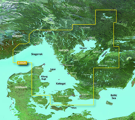
Details: Informationen Produktcode VEU042R Name Oslo-Trelleborg Typ Garmin BlueChart g3 Vision Abdeckung Detailed coverage of the Norwegian and Swedish coasts from Grimstad, NO to Ystad, SE including Oslo, NO and Malmö, SE. Also includes coverage of the Danish coast from Hirtshals through Copenhagen, the Skagerrak, the Kattegat, the Orosund, the island of Laeso, and Lakes Fryken, Vänern, Vättern, Mjörn, Sommen, Nommen, and Bolmen in Sweden. Kompatibilität siehe Reiter Kompatible Plotter Kartenupdate Hier klicken

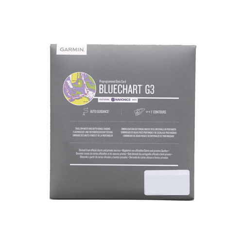
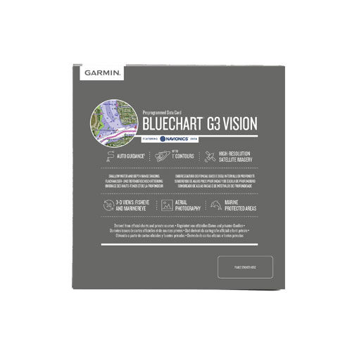
Hoch entwickelte Kartenplotter arbeiten am besten mit hochwertigem Kartenmaterial. Deshalb hat Garmin seine BlueChart-g3Technologie jetzt noch einmal verbessert und BlueChart® g3 Vision auf den Markt gebracht. BlueChart® g3 Vision ist mit den neuen Kartenplottern von Garmin kompatibel: 420/420s/520/520s/525/525S/4008/4012 Die neue g3-Version bietet: Unter Berücksichtigung von Tiefgang und lichter Höhe berechnet AutoGuidance Routenvorschläge. Es kann mit der Funktion "3D Fisheye"ein 3D Bild des Meeresgrundes dargestellt werden. Detaillierte Satellitenbilder sind als Basemap hinterlegt. Topografische Merkmale, Küstenstraßen, Hafenpläne und Stadtgebiete werden noch detaillierter beschrieben und dargestellt. Zusätzlich sind Luftaufnahmen für viele Häfen abrufbar Bei der weiterentwickelten BlueChart® g3 Vision-Marinekartografie können Details auf der Karte in der 3D-Perspektive angezeigt werden, ähnlich der Perspektive des Steuermanns Das System verfügt über eine erweiterte IALA-Navigationshilfensymbolik. Eine optimierte Verwaltung der Kartenkacheln und bessere Einbindung der Kartengrafiken ermöglicht einfacheres Verschieben, Scrollen und Zoomen Intensive Displayfarben und Schattierungen ermöglichen ein einfacheres Ablesen Angaben zu dieser Seekarte: Bezeichnung BlueChart g3 Vision Seekartenmodul REGULAR VEU043R Karteninhalt Includes detailed coverage of all of Iceland including the cities of Reykjavik and Akureyri. Also includes detailed coverage of the Faeroe Islands including Stromo, Ostero, Sydero and Bordo Islands.

Details: Informationen Produktcode VEU046R Name Sweden, South-East Typ Garmin BlueChart g3 Vision Abdeckung Detailed coverage of the south and east coasts of Sweden from Helsingborg to Gävle including Trelleborg, Nykoping, Stockholm, Norrtalje, Karlsborg as well as Copenhagen, DK. Coverage of lakes include Lakes Vänern, Vättern, Sommen, Siljan, Fryken and Helgasjön; as well as coverage of the lower Dalälven from Gysinge to Söderfors and of the Strömsholms Kanal to Smedjebacken. Island coverage includes Bornholm DK, Oland and Gotland SE, and Åland, FI. Finnish coverage also extends to Turku and Hanko. Kompatibilität siehe Reiter Kompatible Plotter Kartenupdate Hier klicken

Details: Informationen Produktcode VEU047R Name Gulf of Bothnia-Kalix-Grisslehamn Typ Garmin BlueChart g3 Vision Abdeckung Detailed coverage of the Gulf of Bothnia from Gavle, SE through Pori, FI including Oulu and Vaasa, FI. Swedish coverage includes Luleå Skärgård, and Lakes Tjeggelvas, Hornavan, Siljan, Aisjaur, Fluka, Uddjaur, Storavan, Revsundssjön and Storsjön as well as coverage of the lower Dalälven from Gysinge to Söderfors. Coverage of the islands of Hailuoto, Vallgrund, and Åland is also included. Kompatibilität siehe Reiter Kompatible Plotter Kartenupdate Hier klicken

Details: Informationen Produktcode VEU050R Name Aland-Vyborg Typ Garmin BlueChart g3 Vision Abdeckung Detailed coverage of the Gulf of Finland from Åland to Vyborg, Finland. Also includes detailed coverage of the cities of Turku, Helsinki, and Kotka in Finland and Tallinn and Kohtla-Jarve in Estonia. Kompatibilität siehe Reiter Kompatible Plotter Kartenupdate Hier klicken

Details: Informationen Produktcode VEU051R Name Lista-Sognefjorden Typ Garmin BlueChart g3 Vision Abdeckung Detailed coverage of the Norway coast from Farsund to Sognefjorden, including the Shetland Islands. Includes detailed coverage of Bergen, Haugesund and Stavanger. Kompatibilität siehe Reiter Kompatible Plotter Kartenupdate Hier klicken

Details: Informationen Produktcode VEU052R Name Sognefjorden-Svefjorden Typ Garmin BlueChart g3 Vision Abdeckung Includes detailed coverage of the Norway coast from Sognefjorden to Afjord. Also includes detailed coverage of Alesund, Kristiansund, Hitra and Trondheim. Kompatibilität siehe Reiter Kompatible Plotter Kartenupdate Hier klicken

Details: Informationen Produktcode VEU053R Name Trondheim-Tromsø Typ Garmin BlueChart g3 Vision Abdeckung Detailed coverage of the Norway coast from Trondheim to Tromsø. Includes detailed coverage for Sandnessjoen, Bodo, Vaeroy, Langoya, Narvik, and Vestfjorden, as well as lakes Tjeggelvas, Hornavan, Uddjaur, Aisjaur, Fluka, Storavan, Revsundssjön and Storsjön. Kompatibilität siehe Reiter Kompatible Plotter Kartenupdate Hier klicken

Details: Informationen Produktcode VEU054R Name Vestfjd-Svalbard-Varanger Typ Garmin BlueChart g3 Vision Abdeckung Detailed coverage of the northern Norway coast from Vestfjorden to Vadso including Tromsø and Narvik. Also includes coverage for Svalbard and approaches. Kompatibilität siehe Reiter Kompatible Plotter

Details: Informationen Produktcode VEU055R Name Finnish Lakes Typ Garmin BlueChart g2 Vision Abdeckung Detailed coverage of inland Finnish lakes including Inarijarvi, Miekojarvi, Simojarvi, and Kiantajarvi. Also includes detailed coverage of Oulujarvi, Pielinen, Saimaa, Paijanne, Nasijarvi, Lohjanjärvi, and others. Kompatibilität siehe Reiter Kompatible Plotter Kartenupdate Hier klicken

Details: Informationen Produktcode VEU060R Name Deutschland Binnengewässer Typ Garmin BlueChart g3 Vision Abdeckung Detailed coverage of the German North Sea and Baltic coast, and the German inland waterway system, including the entirety of the Rhine River, the Main River to Bamberg, the Danube River from Kelheim to Passau in Germany, the Saar River, the Moselle River to Metz, France; the Ems River, the Weser River, the Elbe River to Dresden, the Havel River, the entirety of the Rhine-Main-Danube Canal, the Oder-Havel Canal, the Elbe-Havel Canal, the Elbe-Seiten Canal, the Müritz, the Kiel Canal, the Mittelland Canal, Lake Constance, Lake Zurich and surrounding lakes in Switzerland, lakes in southern Bavaria and Austria including the Chiemsee, Attersee, Neusiedler See and Lake Balaton in Hungary. Kompatibilität siehe Reiter Kompatible Plotter Kartenupdate Hier klicken

Hoch entwickelte Kartenplotter arbeiten am besten mit hochwertigem Kartenmaterial. Deshalb hat Garmin seine BlueChart-g3Technologie jetzt noch einmal verbessert und BlueChart® g3 Vision auf den Markt gebracht. BlueChart® g3 Vision ist mit den neuen Kartenplottern von Garmin kompatibel: 420/420s/520/520s/525/525S/4008/4012 Die neue g3-Version bietet: Unter Berücksichtigung von Tiefgang und lichter Höhe berechnet AutoGuidance Routenvorschläge. Es kann mit der Funktion "3D Fisheye"ein 3D Bild des Meeresgrundes dargestellt werden. Detaillierte Satellitenbilder sind als Basemap hinterlegt. Topografische Merkmale, Küstenstraßen, Hafenpläne und Stadtgebiete werden noch detaillierter beschrieben und dargestellt. Zusätzlich sind Luftaufnahmen für viele Häfen abrufbar Bei der weiterentwickelten BlueChart® g3 Vision-Marinekartografie können Details auf der Karte in der 3D-Perspektive angezeigt werden, ähnlich der Perspektive des Steuermanns Das System verfügt über eine erweiterte IALA-Navigationshilfensymbolik. Eine optimierte Verwaltung der Kartenkacheln und bessere Einbindung der Kartengrafiken ermöglicht einfacheres Verschieben, Scrollen und Zoomen Intensive Displayfarben und Schattierungen ermöglichen ein einfacheres Ablesen Angaben zu dieser Seekarte: Bezeichnung BlueChart g3 Vision Seekartenmodul REGULAR VEU061R Karteninhalt Detailed coverage of coastal and interior France including the coast from Marseille to St. Cyprien, Bayonne to St-Nazaire and La Havre to Dunkirk. Coverage of interior waterways include the Adour, Garonne, Charente, Loire, Seine and Rhone River systems. The Sevre-Nantaise, Somme, Meuse, Moselle, and Saone Rivers, the Rhine from Basel, CH to Karlsruhe, DE; Lake Leman (Geneva), Lake Neuchatel, Lake Biel, Lake Morat, the Canal du Midi, the Canal du Centre and the Rhine-Rhone Canal are also covered.

Details: Informationen Produktcode VEU505S Name Baltic Sea, East Coast Typ Garmin BlueChart g3 Vision Abdeckung Coverage of the coasts of Germany, Poland, Russia, Lithuania, Latvia and Estonia from Rügen, DE to Narva-Jõesuu, EE. Detailed coverage includes the Szczecin Lagoon, Bornholm, the Vistula Lagoon, Kaliningrad, Gotland, the Gulf of Riga, Saaremaa, Hiiumaa, Lake Peipus, and the Mazurian and other Polish lakes including Lake Jeziorak, Lake Łańskie and Lake Śniardwy. Kompatibilität siehe Reiter Kompatible Plotter Kartenupdate Hier klicken

Details: Informationen Produktcode VEU452S Name Adriatic Sea, North Coast Typ Garmin BlueChart g3 Vision Abdeckung Detailed coverage of the Adriatic Sea coast from Trani to Monfalcone, IT southeast to Dubrovnik, HR. Includes detailed coverage of Lago Maggiore, Lago di Como, Lago d'Iseo, Lago di Garda and the Po River from the Adriatic to the Ticino River confluence. Kompatibilität siehe Reiter Kompatible Plotter Kartenupdate Hier klicken

Details: Informationen Produktcode VEU456S Name English Channel, Central-East Typ Garmin BlueChart g3 Vision Abdeckung Detailed coverage of the British coast from Weymouth to Ramsgate including Southampton, Portsmouth, Eastbourne, and Dover; French coast coverage from Saint-Brieuc to Dunkerque, including Saint-Malo, Saint-Vaast-la-Hougue, Grandcamp-Maisy, Le Havre, Dieppe, Le Tréport , and the Seine River to Rouen. Coverage features the Isle of Portland, the Solent, the Isle of Wight, and the Channel Islands of France. Kompatibilität siehe Reiter Kompatible Plotter Kartenupdate Hier klicken